


 2024 results")


While this title may sound like the opening line of an ensuing barroom brawl, my aim to address radar. Just as your airborne radar gives you the ability to point the energy beam up or down (tilt setting), a ground-based radar can be pointed up at varying degrees of slope. In this article, I will talk about the different views of precipitation that ground-based radars can provide and how they can be used by pilots. The point of this discourse is to ensure that when you are using ground-based radar for pre-flight decisions, you are seeing the truest, or best picture, of convective precipitation. To get your best picture, you have to look in the right place.
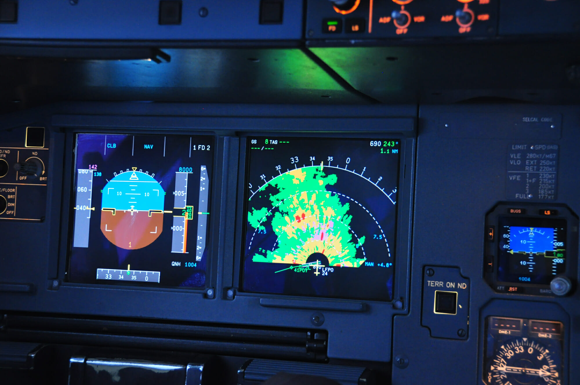
We don’t fly ground-based radars
We do however use ground-based radars to make certain preflight decisions. If we are among the fortunate, we can see ground-based radar displays while airborne too – thanks to ADS-B. Either way, when viewing ground-based radar imagery, you need to be cognizant of what it is you’re looking at.
Base Reflectivity vs. Composite Reflectivity


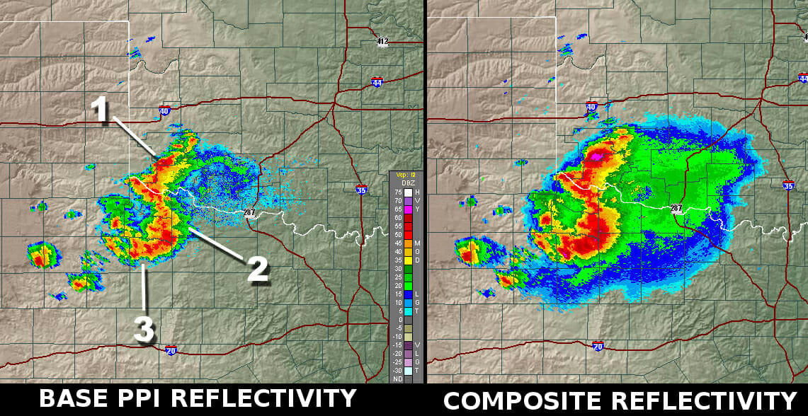
There are two kinds of images ground-based radar makes available for analyzing weather echoes. In simple terms, one kind of image shows a lower section of a precipitation return. It is not scanning all the way up, so to speak. In the other kind of image, a fuller scan or more volume of a precipitation echo is being analyzed by the radar – a bigger picture. Technically speaking, one image is using a lower tilt setting, the other a higher. The two kinds of scans/images/reflectivity are:
A BASE REFLECTIVITY scan is looking lower.
A COMPOSITE REFLECTIVITY scan is looking higher up at the “bigger picture.”
By comparing these two images, you can sometimes see certain general details about storm and precipitation structure that might aid your decision making which can prove very beneficial, especially when a large area is affected by convection.
The illustration below shows the difference between the two:
And these helpful links will provide information for learning more about Doppler radar:
https://www.weather.gov/jetstream/radarfaq#diff
https://www.weather.gov/jetstream/how
When you’re in pre-flight mode and analyzing convective weather, be sure you are looking at both the BASE and COMPOSITE scans. The COMPOSITE scan will often show you higher level precipitation that is anvil related. This ability to see higher up may provide options for low-altitude routes and deviations. In simple terms, the BASE REFELCTIVITY image allows you to see the individual cell whereas the composite shows you the cell and anvil precipitation.
Applied principal
For a flight from ATW to ORD, I took a look at the radar before taking off. The area was heavily affected by convection. A look at the composite radar image showed the entire area covered in precipitation. By all regulatory, SOP guidance, it looked undoable. A switch to the base reflectivity however, showed the storm structure very well and made the actual individual cells very visible which showed a vastly different picture.
While the route from ATW to ORD was still somewhat circuitous, it was doable based on the comparison of the two different radar views. As such, we were able to keep a wide berth from the individual cells laterally and were able to choose a lower (11,000 feet, in this case) altitude to stay away from the anvils (convective debris).
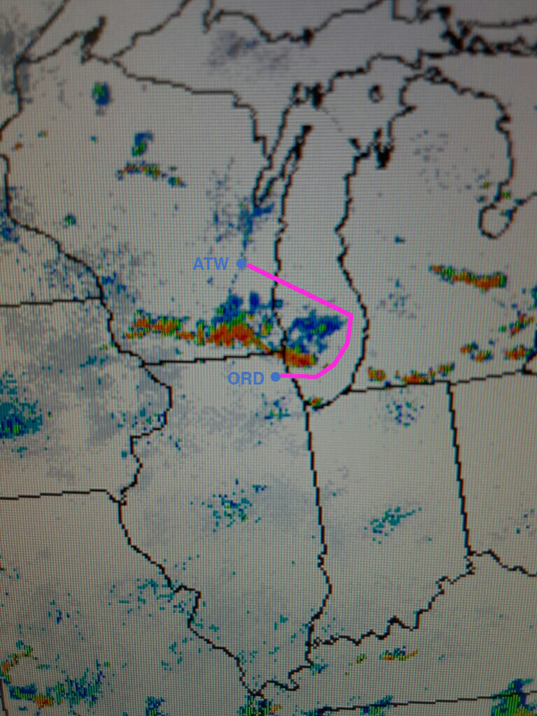
This was made possible by comparing both radar images. I share this example to demonstrate my own learning experience that was made possible through diligence and care. Had I only looked at the composite image, I would have opted to further delay the flight. Instead, I looked around and found that the flight could be safely completed.
Bottom line
There is a great deal to learn about weather radar, ground and airborne. The shared links will provide a great deal of information about ground-based doppler radar. These links take you to the real authorities on the subject of weather radar – the NWS and NOAA. My purpose is to facilitate your knowledge.
Increasing your depth of knowledge should include a basic analysis of weather echoes that you can employ before (and possibly during if you have access to ADS-B) a flight. By seeing different pictures of the same things, you might be able to make more prudent and safer decisions.
Finally, it is my opinion, expressed through this and other articles that I have written for Aero Crew News, that one of the most important tools in an “all-weather” airplane is the weather radar. We should all be very proficient in its use. Let’s expand our knowledge of ground-based radar, as well.


 2024 results")


